SRT RSS Feed

Mullinville, Kansas…A Favorite Wrong Turn

Tumbleweeds the size of boulders streak past in all directions causing me to involuntarily close my eyes and make darts to the left or right behind the safety of the windshield. One sticks on the hood ornament and I lurch back with enough force to strike the head rest and then bounce back to an upright position. My motions would appear silly to anyone watching, but there isn’t anyone. I’m lost.

Travel writers and guides never fail to recommend getting lost in such places as Marrakesh or Seville. All those twisty narrow lanes of mystery lead to experiences that fully engage the senses. Maybe not always gently; sometimes “onslaught” is a more accurate description. Onslaught or not, a memory is etched. THAT is the essence of travel.

Getting lost gives the experience an “edge”, an emotional jump start. And road trip travel in places like Kansas is no different. Really. Those twisty narrow lanes of mystery in places with exotic names have nothing on what you can stumble across in Kansas.

The first time through Mullinville was a mistake.  If you read that sentence carefully, it’ll tell you that a second time was on purpose because the first trip was rewarding enough to go back.

Careful of my speed limit through the small town, I’d just begun picking up speed when I see this:

Heavy Metal Highway -- Mullinville, Kansas

“What the?!” The wind is doing its best to alter the footing of the 5,000 lb. Yukon as I pull off the road. The sun is full-on but the barren landscape broken by the freaky signs, the desperate squeak of whirling buckets suspended as high into the Kansas atmosphere as the strength of a metal pole will support, the flags flapping out of unison, all screechingly collide into one perfectly produced Twilight Zone scene.

It’s October so I pull on a jacket before picking up camera gear, zip it completely (I’ve learned a few things about Kansas wind), and get jerked out of the truck onto my side because I’ve learned a lot about jackets and Kansas wind, but I’m still learning about the wind powering open a truck door. I don’t bother looking around. There’s no one to have seen me.

After gawking for sometime and taking in all the symbolism and dark humor, I begin taking photographs. A local barrels by on the highway and honks (he obviously knows the local law enforcement). His intrusion confirms I’ve not really landed in a Twilight Zone episode.

One year later…

IMG_5563 copy

IMG_5552 copy

IMG_5565 copy

IMG_5557

There will be a 3rd trip. I still don’t have the shot I really want. Maybe a Fisheye?

Want to see all this for yourself? Head west on 54/400 out of Wichita, through Pratt. Mullinville is 41 miles west of Pratt, 120 miles west of Wichita.


Update: USAToday Picture America Contest

The Black & White photo taken during my March 2009 solo road trip, didn’t place in the Top 3 of the public voting (as you can imagine, the competition was top-notch). I’ve known about this for several days and while slightly disappointed, was grateful and humbled to have been given the Top 10 nod by the professional judges who sorted through the thousands of submissions.

Having moved on to other projects, like writing, the contest was behind me. Until today. John Batdorff, a professional photographer with whom I’ve recently connected alerted me to the fact the 10 Finalists were posted on the USA Today website, with comments from the three professional judges [who initially narrowed the submissions down to the Top 10.]

My consolation for not having garnered enough public support for a top 3 finish are these comments from the judges:

“Finalist: Walkway to the West in the American High Plains by Tammie Dooley of Tulsa, Okla. The judges, who would have picked this as the second-place winner, were struck by its “great mood – stormy, majestic, dramatic – emphasized by the drama of black and white. It draws you in and pushes you away at the same time, challenging you intellectually.” The found it emblematic of the high plains and prairies so unique to the American landscape. “The whole middle of the country is represented here,” they said.”

Good enough for me!

The photo is a winner thanks to all of your comments, encouragement, support and for slogging through the not-so-user-friendly USAToday website to log votes.

**Thank you for your votes and kind words! And congratulations to the winners!!  The Top 3 photos are stunning and deserve the win.**

P.S. abcnews.com has asked for permission to reprint the photo (as a member of the 10 Finalists).  Will keep you posted!! Nothing like getting a lot of mileage from one click of the shutter. LOL

The Badlands?

Walkway to the West - The American High Plains

The Enchanted Highway

North Dakota’s Enchanted Highway is 32 miles of soaring, metal art sculpture that qualify as some of the largest in the world. They are as unusual as they are enjoyable, qualifying unequivocally as must-see Americana Road Art. But the highway isn’t about the objects at all. North Dakota’s Enchanted Highway is about a MAN and his singular vision.

Deer Crossing

“Deer Crossing”. The buck is 75-feet tall and 60-feet long. Erected in 2002. Made from old oil well tanks cut apart and welded to form the shadow design. To fit through the streets of Regent, the buck’s front leg had to be cut off and re-welded on-site.

Small town characters/sometime heroes are sometimes an odd lot. My husband and I swap stories about the characters from our respective small towns – his in West Virginia, mine in SE Oklahoma. Those characters, as we call them, were a bit different, marched to the beat of a not-so-audible drum, hardworking, kind, and talkative. In a small town these individuals are part of the community’s colorful tapestry. They are a clean stamped part of the puzzle, fitting in while not being forced to lose their identity. And while this is commendable of small towns, they are at the same time frequently guilty of speaking from both sides of their mouth. On the intake they can welcome uniqueness with invitations to “come here” while on the exhale uttering whispers of displeasure and not-so-silent “get aways.”

Gary Greff is a small town character. I only hesitate to say “hero” as I feel I don’t know enough of the story. However if you judge such things based not on the outcome but intent and the effort expended, then Gary qualifies. Near 60, Gary hails from a small town to which he was never able to break the tether (Regent, ND), lives below the poverty line but is tenaciously steeped in hope for his own life and for the survival of his hometown, and has spent the past 20 years fighting for a vision of betterment for his community. His young life in Regent was re-directed by tragedy. At 16, driving a motorbike with his 15 year old brother on back, Gary hit a curb in town. His brother died at the scene. People’s lives are shaped by such.

After teaching school in various communities, at age 40 Gary moved back to Regent led by a vision to do something to curtail the demise of his hometown. He’d never pursued art of any kind. He couldn’t weld. And yet the sculpture below made it into The Guinness Book of World Records as the World’s Largest Metal Art Sculpture. It’s 110 feet tall, 154 feet long and weighs 79 tons. And photographs like any beautiful piece of art.

Geese in Flight

Geese in Flight

Tin Family

“Tin Family”. The man is 45-feet tall; the woman 43-feet tall; and the boy 23-feet tall.

Teddy Roosevelt Rides Again

“Teddy Roosevelt Rides Again”. 51-feet tall. A tribute to President Theodore Roosevelt’s part in North Dakota history. Built from used oil well pipe.

Fisherman's Dream

“Fisherman’s Dream” (my personal favorite).

Pheasants on the Prairie

“Pheasants in the Prairie”. Rooster is 70 ft. long, 40 ft. tall. Made of wire mesh that was originally used for screening gravel. Long process — took 3 years — the wire was heated and bent to form the bodies.

Grasshopper's Delight

“Grasshopper’s Delight”. 60 Feet long, 40 Feet tall. A reminder of the hardships farmers have overcome making their living off the land. Welded from old fuel tanks and oil well tanks.

Gary Greff between 1989 and 2006 did all of this. And he did it amid harsh criticism, ridicule, accusations of insanity, the scorn of fellow townsfolk, one rebuff after another, and over time a severely curtailed financial and volunteer donor list. His brother Brad said, “people walked across the street to avoid him”. He did, what no other townsperson in Regent, ND has been able to do – he drew people to the area. And continues to.

Gary’s art didn’t save Regent in the way he’d envisioned. The High School closed. The town appeared to me to be a rural American small town clutching survival when I saw it in March 2009. Gary’s dream for an Enchanted Highway Theme Park and droves of tourists dropping their money in Regent hasn’t materialized. But his vision, hard work and undying commitment left a commendable and very memorable mark. Gary Greff is the best kind of dreamer – he takes action.

To see the Enchanted Highway and Gary Greff’s art, take Exit 72 (about 20 miles east of Dickinson, ND) off of I-94. The Highway runs due south from there and ends in Regent.  There is no charge so if you see a contribution box, leave some currency behind.

“No one, I discover, begins to know the real geographic, democratic, indissoluble American Union in the present, or suspect it in the future, until he explores these Central States, and dwells awhile on their prairies or amid their busy towns.” – Walt Whitman

Heartland Chronicles is a series of radio documentaries set in and around Middle America, exploring the region’s people and communities. A concentrated focus on this region allows us to draw what author William Least Heat Moon refers to as a “deep map” – a careful, long-term exploration of place that reveals the truth of everyday life today. Here’s the 2005 interview with Gary Greff (the MP3 choice seems to work best).

Join the Road Trip Revolution at the Solo Road Trip Facebook Fan Page, here.

Of Rattlesnakes & The Geographic Center of the U.S.

Clamoring on the steep incline under the weight of my heaviest film camera (reserved only for the most promising of discoveries), slipping twice to one knee on rime ice, I hitch one last gasp of frigid oxygen as my head lifts my eager eyes into perfect position to feast on the conquered monument. Sheepherder’s Monuments!? !*&#@%! “This is NOT the Geographic Center of the United States of America??!!” My lips are too numb to spew anything out, but my mind handles it beautifully in their stead. “I climbed all this way, alone in the middle of Greenland, South Dakota for THIS!?” Kicking the fence while hanging on with one gloved hand to steady my footing, the shards of ice and frozen atmosphere target the only opening to my skin, right down the back of my neck. And if there’s any justice, hopefully into the dens of a few sleeping rattlesnakes.

“Sheepherder’s Monuments or stone Johnnies survive the days of the open range. These stone columns were probably built to indicate distance and direction to waterholes and provided the sheepherder with a pastime while herding his flocks.”

The Geographic Center of the U.S. is not where you’d expect. Furthermore, it’s not where my 2004 Atlas said it would be. After spending an hour-and-a-half combing the area, I know. North of Belle Fourche (Bell Foosh), South Dakota on Highway 85, just South of Junction 168, my Atlas in bright red said: “Geographic Center of U.S. Marker”.

From setting my sights on a grandiose solo road trip self-portrait at the geographic center of the United States of America, the search dwindled to looking for something as tell-tell as a unique T-Post in the frozen fence line. Incredulous the grandiose was not forthcoming, I became desperate to find something and perplexed as to what could have happened to a marker of such importance. Blood pressure increasing, my eyes landed on the remnants of an old paved road. No gates, no signs, with just enough pavement and old footings to indicate something of note stood here at one point, I excitedly drove around the site to get my bearings. Perched above the disintegrating pavement and towering above the prairie was an area surrounded by a menacing fence. Without question this was something the Department of Interior had gone to great lengths to protect — I’d discovered it after all.

Confused? So was I. So here’s my best shot at an explanation. But I warn you, there’s not a lot of authoritative research to rely on and a lot of what follows is disputable. In 1959 the U.S. Coast and Geodetic Survey officially designated a point 13 miles north of Belle Fourche, South Dakota as the Geographic Center of the U.S. (which includes Alaska and Hawaii). The location was surveyed at: Latitude 44 degrees, 58 minutes North, and Longitude 103 degrees, 46 minutes West.  Any marker grander than the requisite USGS benchmark in the ground was up to the state of South Dakota to provide and maintain. Around the same time, maybe AT the same time, the Department of Interior built the Monument marker and fence (since it’s on Bureau of Land Management land) for the nearby high-plains cairns of Sheepherder’s Monuments. The State of South Dakota then proceeded to build a picnic area, restrooms, etc. on the site and sold tickets billed for seeing both monuments. Recall previously I mentioned the footings for buildings and the video shows restrooms.

The rattle snakes must have felt they weren’t being cut their fair share and laid claim to the area. Either the Department of Interior, the state of South Dakota or both, closed and abandoned the Sheepherder’s Monuments’ area in the mid-1990’s.  Solo road trippers, caution is ALWAYS justified and should NEVER be disparaged. What you don’t know can kill you. There were no signs warning of rattlesnakes. Had I gone in any of the 3 other seasons of the year…well, I was wearing hiking boots. Given that I’m here to tell this tale, I learned a lesson and should I be faced with such a situation again, I will recall this hell-bent mission to see something and hopefully make a good decision.

Eventually the Belle Fourche Chamber of Commerce approached the National Geodetic Survey with a plan to build a new concrete and granite marker IN the town of Belle Fourche making it easier to share the marker with the world. The National Geodetic Survey agreed to the new location and contributed the stainless steel centerpiece of the monument. It was unveiled in 2007.

The original marker STILL LIES 13 miles North of Belle Fourche off highway 85 on someone’s fence row, seldom visible, and is but a footnote in history, if that.  It’s the marker I want to see.

The official bronze mark made in 1959

The original USGS benchmark made in 1959 — NOT my photo.

Of Rattlesnakes & The Geographic Center of the U.S.

From the top of Sheepherder’s Monuments. While not locating the Geographic Center of the U.S. marker, seeing Sheepherder’s Monuments, in retrospect turned out to be a very exciting find. I’m glad I made the trek.

Aces & Eights

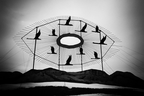
Walking around with thumbs hooked in my front belt loops makes it difficult to fire off shots. Camera shots of course. Spending a good deal of time with nose to pistol case windows, my mind plays out a fantasy of swishing down the dirt streets with a long, black duster one side tucked to reveal a fancy hand-tooled holster and matching silver plated, ivory handled Colts. It would be difficult however to win a gun fight with my black hat tipped this low over my eyes. The same tender spot on my forehead would likely result from tipping the hat back and forth, similar to the stocking hat incident in the Badlands. Not cool.

Deadwood, South Dakota

Burned to the ground in 1879, Deadwood was rebuilt on the burned out remains. The original town sits about 10 feet lower than street entrance today.

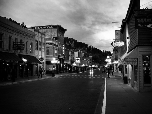
Resistance to the Wild West aura of Deadwood, South Dakota is futile my friend. You will be sucked in. And glad for it.

Designated a National Historic Landmark in 1961, in the 1870’s lawlessness defined Deadwood. Illegally settled on Native American Land as a result of Custer’s discovery of gold in the Black Hills, gambling, prostitution, gunfights, and general mayhem was the order of the day. Which is juicy enough, but the town gained its current fame upon the murder of James Butler Hickok, aka Wild Bill in 1876.

xoxoxo

The Historic Adams House was built in 1892 by Deadwood pioneers Harris and Anna Franklin. Local contemporary press described the home as “the grandest house west of the Mississippi.” Today the house operates as a museum devoted to the history and culture of the Deadwood area.

Deadwood Courthouse on a March Morning

Deadwood Courthouse on a Modern March Morning

While in several notable gunfights, Wild Bill was NOT an outlaw, although his penchant for gambling overlapped nicely with his law enforcement duties. [You know that deserves a chuckle.] Wild Bill had many callings: abolitionist, facilitator of the Underground Railroad Movement, lawman (serving as a US Marshal at Ft. Riley, Kansas for a short period, sheriff of Hays, Kansas and marshal of Abilene, Kansas), gambler, veteran of the Union Army in the American Civil War, and scout. Holding the infamous “dead man’s hand” of two Ace’s and two 8’s, (the 5th and last card having been undealt), he was gunned down from behind by Jack McCall during a poker match. Wild Bill was 39. McCall hanged on March 1, 1877 for the murder.

Wild Bill’s life began in Illinois. He traveled from there to Kansas, Nebraska, Missouri, Indian Territory (Oklahoma), New York, Wyoming, and South Dakota. An interview published by Harper’s New Monthly Magazine in 1865, another by Henry Morgan Stanley a Welsh journalist and famed African explorer in 1867, and later being cast as the hero of the earliest dime store novels, resulted in Wild Bill becoming one of the first international celebrities. For someone aged 39 at a time when most travel was at 3-7 miles per hour, his life covered a whole lot of ground.

Several locations claim to be THE spot where Wild Bill was shot. I chose this one well, because it made a great shot!

Several locations claim to be THE spot where Wild Bill was shot. I chose this one well, because it made a great pic!

Original Wild Bill Gravesite

Original Wild Bill Grave Site

Wild Bill Hickok? Buffalo Bill Cody? Calamity Jane? Wyatt Earp?  Did they know each other? What were the connections? What was the timeline on these American West Icons?

Let’s start with Calamity Jane – there’s got to be a woman mixed up in all this, right?! Martha Jane Cannary, aka Calamity Jane, a frontierswoman and scout became friends with Wild Bill Hickok in Deadwood, South Dakota. While Calamity Jane purportedly claimed they married and Wild Bill fathered a child, these claims have never been proven. Most historical accounts indicate Jane was indeed infatuated with Wild Bill but the romantic liaison was fabricated. Calamity Jane later became a horse rider and trick shooter in 1893 for Buffalo Bill Cody’s Wild West Show. She died in 1903. Her dying wish was to be buried next to Wild Bill Hickok. She now lies interred beside him in Mt. Moriah Cemetery, Deadwood, South Dakota.

Wild Bill Hickok met Buffalo Bill Cody (purveyor of the Wild West Show that gained international fame in the late 1800’s) during their short but common stint with General Jim Lane’s vigilante Free State Army (“The Red Legs”) in 1855. Buffalo Bill was only 12 years of age, scouting (reconnaissance) for the General. Wild Bill was 21. They became life-long friends, their paths crossing many times before Wild Bill’s demise in 1876. Wild Bill played a part in Buffalo Bill’s show “Scouts of the Plains” along with Texas Jack in 1873. They left the show circuit well before the famed “Wild West Show” began.

Wild Bill Hickok, Texas Jack, and Buffalo Bill Cody

Wild Bill Hickok, Texas Jack, and Buffalo Bill Cody. 1873.

In 1871 Wild Bill Hickok and Buffalo Bill Cody met Wyatt Earp for the first time in Kansas City. Wyatt claimed Wild Bill helped him become a skilled buffalo hunter. Wyatt met Bat Masterson on the open Kansas prairie during a hunt on which Wild Bill accompanied him. While there’s not much documentation indicating their paths crossed much, Wyatt said of Wild Bill “Bill Hickok was regarded as the deadliest pistol shot alive as well as being a man of great courage. The truth of certain stories of Bill’s achievements may have been open to debate but he had earned the respect paid to him.”

To put all their ages in perspective, Wild Bill Hickok was the oldest being born in 1837.  Buffalo Bill Cody and Wyatt Earp were 9 years younger than Wild Bill with birth dates in 1848. Calamity Jane, born in 1852 was 15 years younger than Wild Bill.

Mt. Moriah Cemetary. Deadwood, South Dakota. Final resting place for Wild Bill Hickok and Calamity Jane.

Mt. Moriah Cemetery. Deadwood, South Dakota. Final resting place for Wild Bill Hickok and Calamity Jane.

This shot was literally “captured”.  Fortunately, I wasn’t. Breakin’ the law.

Today Deadwood is a mecca for gambling with every false storefront tucking away a casino. If you’re a gambler, then any time of year works. If you’re not (I’m not), I’d recommend October. This last visit was only weeks ago in March and while it was off-season as far as crowds go, it was also cold enough to keep most people inside. And that’s NOT where you want to be.  October was divine. I had Main Street to myself.  Sitting on a bench one evening, the stars bright overhead, gazing down the lamp lit street, I was transported to another place and time.

I went to bed viewing the scene above from my hotel room window. The black duster thrown over the back of an imaginary chair, the matching Colts on an imaginary table, I slept with a smile on my face.

Join the Road Trip Revolution at the Solo Road Trip Facebook Fan Page, here.


The Grand Climb


Tammie DooleyAbout SRT... I’m a traveler, writer and photographer for whom the open road frequently summons. Adventurous solo road trips are a staple for me, and a curiosity. So I created this website to share them and inspire you to step out and give them a try. Welcome!

A soul that sees beauty may sometimes walk alone – Wolfgang Von Goethe

  • Categories


  •  

    Connect with SRT

    RSS Connect on Twitter Subscribe by Email
    Email me
    Become a SRT Facebook Fan
    Follow me on Twitter
    See my photos on Flickr

    I want to hear from you!
    ~ Tammie


    World Reviewer adventure travel blogs