
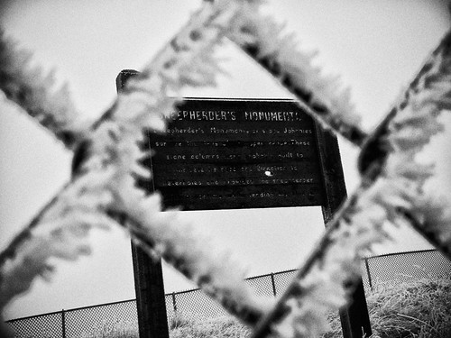
Clamoring on the steep incline under the weight of my heaviest film camera (reserved only for the most promising of discoveries), slipping twice to one knee on rime ice, I hitch one last gasp of frigid oxygen as my head lifts my eager eyes into perfect position to feast on the conquered monument. Sheepherder’s Monuments!? !*&#@%! “This is NOT the Geographic Center of the United States of America??!!” My lips are too numb to spew anything out, but my mind handles it beautifully in their stead. “I climbed all this way, alone in the middle of Greenland, South Dakota for THIS!?” Kicking the fence while hanging on with one gloved hand to steady my footing, the shards of ice and frozen atmosphere target the only opening to my skin, right down the back of my neck. And if there’s any justice, hopefully into the dens of a few sleeping rattlesnakes.
The Geographic Center of the U.S. is not where you’d expect. Furthermore, it’s not where my 2004 Atlas said it would be. After spending an hour-and-a-half combing the area, I know. North of Belle Fourche (Bell Foosh), South Dakota on Highway 85, just South of Junction 168, my Atlas in bright red said: “Geographic Center of U.S. Marker”.
From setting my sights on a grandiose solo road trip self-portrait at the geographic center of the United States of America, the search dwindled to looking for something as tell-tell as a unique T-Post in the frozen fence line. Incredulous the grandiose was not forthcoming, I became desperate to find something and perplexed as to what could have happened to a marker of such importance. Blood pressure increasing, my eyes landed on the remnants of an old paved road. No gates, no signs, with just enough pavement and old footings to indicate something of note stood here at one point, I excitedly drove around the site to get my bearings. Perched above the disintegrating pavement and towering above the prairie was an area surrounded by a menacing fence. Without question this was something the Department of Interior had gone to great lengths to protect — I’d discovered it after all.
Confused? So was I. So here’s my best shot at an explanation. But I warn you, there’s not a lot of authoritative research to rely on and a lot of what follows is disputable. In 1959 the U.S. Coast and Geodetic Survey officially designated a point 13 miles north of Belle Fourche, South Dakota as the Geographic Center of the U.S. (which includes Alaska and Hawaii). The location was surveyed at: Latitude 44 degrees, 58 minutes North, and Longitude 103 degrees, 46 minutes West. Any marker grander than the requisite USGS benchmark in the ground was up to the state of South Dakota to provide and maintain. Around the same time, maybe AT the same time, the Department of Interior built the Monument marker and fence (since it’s on Bureau of Land Management land) for the nearby high-plains cairns of Sheepherder’s Monuments. The State of South Dakota then proceeded to build a picnic area, restrooms, etc. on the site and sold tickets billed for seeing both monuments. Recall previously I mentioned the footings for buildings and the video shows restrooms.
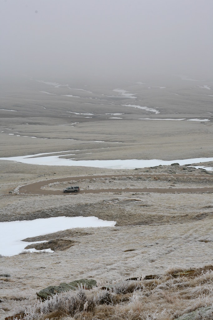
The rattle snakes must have felt they weren’t being cut their fair share and laid claim to the area. Either the Department of Interior, the state of South Dakota or both, closed and abandoned the Sheepherder’s Monuments’ area in the mid-1990’s. Solo road trippers, caution is ALWAYS justified and should NEVER be disparaged. What you don’t know can kill you. There were no signs warning of rattlesnakes. Had I gone in any of the 3 other seasons of the year…well, I was wearing hiking boots. Given that I’m here to tell this tale, I learned a lesson and should I be faced with such a situation again, I will recall this hell-bent mission to see something and hopefully make a good decision.
Eventually the Belle Fourche Chamber of Commerce approached the National Geodetic Survey with a plan to build a new concrete and granite marker IN the town of Belle Fourche making it easier to share the marker with the world. The National Geodetic Survey agreed to the new location and contributed the stainless steel centerpiece of the monument. It was unveiled in 2007.
The original marker STILL LIES 13 miles North of Belle Fourche off highway 85 on someone’s fence row, seldom visible, and is but a footnote in history, if that. It’s the marker I want to see.

Visited yesterday. Sunny and in the 70s. No rattlesnakes. Just a fun hike and beautiful views.
Comment by Allen Bartell — September 11, 2020 @ 9:59 am
[…] south of Rapid City, 385 will take you to Lead (as in lead a horse to water), Deadwood, the Geographic Center of the U.S. in Belle Fourche, and Sturgis to the East just off Highway 90. Either of these towns is worthy of securing […]
Pingback by 25 memorable sights: The Black Hills | Tiketjakarta.com — September 14, 2012 @ 2:09 pm
[…] south of Rapid City, 385 will take you to Lead (as in lead a horse to water), Deadwood, the Geographic Center of the U.S. in Belle Fourche, and Sturgis to the East just off Highway 90. Either of these towns is worthy of securing […]
Pingback by 25 memorable sights: The Black Hills — July 3, 2012 @ 4:38 pm
the geographic centre, was that did you find that by magnetic compass or north compass?
cool.
Comment by Laura Brisbane — May 24, 2010 @ 7:14 pm
WOW.
As an Australian, the idea of a randomly coming across a rattlesnake is just crazy. Are there any areas of the US that don’t have rattlers that will just pop out from behind a bush at you??
Cheers 😀
Comment by Laura Annerley — May 10, 2010 @ 8:31 pm
Don’t be dissapointed!! after all you found the middle of nowhere! haha. I admire you going all the way up with this cold and wind!! Can imagine your dissapointment!
Comment by Bogaugon — May 17, 2009 @ 2:37 pm
Tammy, It’s the unexpected finds that in retrospect as you have now found, are the memories we will have with us longer than the expected! I always try to be open for the “disappointment”… hoping to realize it really is a treasure in disguise! Your my kind of explorer!
Comment by Chessie — May 15, 2009 @ 12:30 pm
Just browsing your lovely photos and prose once again…
Comment by jen laceda — May 13, 2009 @ 8:46 pm
Glad the snakes didn’t get you. I assume they got the sheep. Keep treking. Love seeing the world through your eyes.
Comment by Pops — May 13, 2009 @ 7:44 pm
Looks like it’s still pretty cold up there! I’m down in Texas at the moment, and I’ll trade you some water moccasins for your rattlesnake. =P The last photo gives a real sense of breathlessness – sharp, cold mountain air. I miss that kind of feeling. Once I’m done on this job, I’ll be headed through that area on the way back home to Montana. I’ll have to take a lot of photos =)
Comment by JD Mion — May 13, 2009 @ 6:39 am
One of the best posts you’ve made. Not only was this post educational, but entertaining as well. Glad to know you want to find the original marker. I can’t wait to read that post! Good luck!
Comment by James — May 11, 2009 @ 9:06 am
HI, sorry if I’m MIA here for a bit. Been travelling and sometimes, wifi is just soooooo slow. Will connect back when I get home (or with good wifi)
Comment by jen laceda — May 7, 2009 @ 8:17 pm
Woah…I agree with the others, you are brave and tenacious!
Comment by Tina of Pfeiffer Photos — May 6, 2009 @ 9:44 pm
Jim — Missile silos! Why can’t I stumble across something as cool as that instead of rattlesnakes!
Alex — It can still be felt, can’t it? History may get buried in fence rows and tall grass, but it’s not going away. After this last bit of digging on the Sheepherder’s Monuments/Geographic center, and the research done on Wild Bill, et.al., I have new found respect for historians. I also have more reason than ever to question what some claim as indisputable. No such thing.
Clay Mama — Of course I’m going back to find it. You passed down the explorer gene, remember?!
Comment by Tammie Dooley — May 6, 2009 @ 2:31 pm
My family and I lived in Belle Fourche for about a year back in the early 60’s. Amidst all the prairie grass, sheep, and snowy desolation lies more than a few missile silos. You won’t find those on any tourist info that I know of.
Comment by Jim Wharton — May 6, 2009 @ 10:06 am
Serendipity. Here in the one time Western Frontier of Ohio, there are monuments in place of Harrison’s forts. Some are the actual buildings, others you can find if the grass has recently been cut. Still, when the line is followed, history can be felt. Sometimes the visions of troop movements (in this case a hell of a lot of retreating) can be felt.
Awesome post.
Comment by Alex Crabtree — May 6, 2009 @ 9:54 am
Bleak looking place in wintertime.! Rattlesnakes! You are one determined gal. And I have to assume you will be going back to search for it. Please, take someone with you.
Comment by Clay Mama — May 4, 2009 @ 2:56 pm