
The Dakotas, U.S.A.
An 8-day Solo Road Trip to the Dakotas? In March? Word was the Badlands had snow. I wanted to see this even as I recognized it wasn’t the best time of year to head North. So I packed for the unexpected and directed the truck Northwest determined to find adventure and image treasures. Most of the snow had melted in the South Dakota Badlands, a blizzard caught me near Fargo, North Dakota, it was MINUS 9 degrees for a couple of days, and well, the trip was everything I expected, and more! Undeterred by the lack of snow frosting the rather drab wasteland of the Badlands, I found other treasures. Unexpected treasures, like the one below.
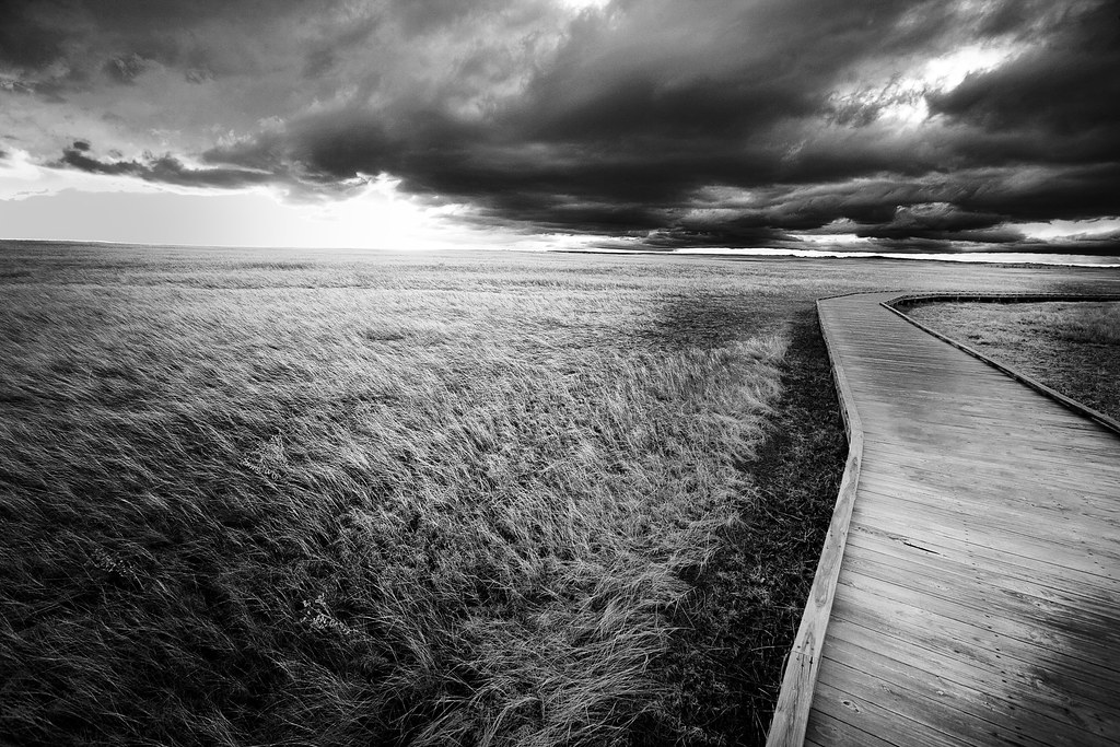
South Dakota Badlands -- The Unexpected -- Delightful!
Mysterious Light Source, or God’s Mirror?
See that spot of light? You know the one. Photographers and visual artists may wax on about light, where and when it’s the “best”, and have the world believe they see something more mystical than the average human can appreciate, but you know better. While some indeed possess a highly trained eye for the details, you’ve seen the spot of light too. And your appreciation for it is no less than the artist’s. You’ve been out walking the dog, feeding cattle or raking hay, fishing, golfing, hiking, climbing a mountain, working in your garden, playing with a child, walking in a park, traveling, or merely walking to your car from the office and you glimpse it – a concentrated brightening of something. It’s illuminated by a source of light you can’t readily identify.
I liken the search for the source to that of finding your way with the proverbial rope between the house and the barn in a blizzard or in my case being raised in Oklahoma, one of the dust bowl’s infamous dust storms. You discover there’s a crack the sun has snuck between. It may be a parting of foliage or a break between buildings. It may even be indirect in the form of reflection. Mysterious light is a joy to encounter. Every time I do I’m intrigued by what the tiniest bit of light reveals, from where it sneakily emanates illuminating that which would not otherwise be illuminated at any other time of the year.
South Dakota Badlands, by Tammie Dooley
This winter I caught a bit of stray light on a small tree carving in the backyard. The spot of light hit the carving on the opposite side of the setting sun. Perplexed I walked up to the carving and began examining it. Running my hand along the rope of light I finally traced the source to a reflection off a back porch window. The source was indirect! The setting sun struck the window of the house at just the perfect angle to reflect back and illuminate the carving. By the time I’d completed the treasure hunt, the sun had moved and the entire carving was in shadow. I prepared to photograph the highlighted carving the next day at the same time only to discover what Ruth Bernhard discovered with her famous photograph of the doorknob.
“The story goes that this glass knob, affixed to her garden gate, struck her one May morning for the riotous halo of refraction it displayed. She made a note to photograph it the next day around the same time. But revolving around the sun as we do, the knob refused to glow in just that way the following morning. Bernhard made a notation on her calendar and exactly one May later was at the ready when the knob did its annual ray-dance. This time she caught it, as is her preference, in one take.” — Women In Photography.Org
For the above picture I’d driven most of the day in 20 degree, windy, gray weather to find a spot suitable to shoot the Badlands at sundown. Actually I’d driven 14 hours the day before just to ensure I’d have this day to scout a position for a sunset shoot. In and out of the truck countless times to visit an overlook or hike down some path, without the sun to direct me I had to keep reminding myself if the clouds parted at all, what side of the desolate wasteland would be illuminated by that glorious light of the setting sun. The Park was deserted so no one noticed my repeated drive-bys, turn-arounds, and general appearance of lunacy.
I settle on a spot, park the truck, stack on layers of warmth, cinch down my hood, sling gear on my back and hike through creamy, slick, off white mud, set up my tripod and begin the wait. The wind buffets the camera anchored to the tripod. My eyes and nose flow from the sting of the cold air. My stocking hat keeps slipping down over my eyes from the parka’s tightly cinched hood. The friction of moving it back repeatedly all day has rubbed a tender spot on my forehead that now seems all the more raw and annoying in the cold. Yet I watch and wait. Having been in the Park all day waiting for this, I will not head to the motel without giving every effort to the goal. The light changes. I look around to identify the source and then return to setting up the frame since I know the magic moment will be here and gone in an achingly quick instant. I take 3 frames. The scene holds. Again I pause to glance around for where the light emanates. There is no crack in the clouds from where I stand. Two more frames and the scene slips away into the monotony of dusk. Reversing the order of the previous actions I trudge back to the truck disappointed I’ve not captured the characteristic sunset shot. Taking several minutes to kick and scrape some of the muck off my boots, store the tripod, take off the heavy coat, stocking hat and gloves, I’m now so tired the thought crosses my mind to not review the photos. My heart bypasses that silly idea and in the warmth and safety of the running truck I switch on the camera’s reviewing screen. The 3rd frame takes my breath away. Happy tears come to my eyes at the ethereal capture held like magic in my camera.
There’s never been an instance where I could not follow the rope to the light source. Until this. I choose to explain the light source as God’s Mirror. And that suits me just fine.
“The most beautiful object is not beautiful unless the light reveals what is there.” – Ruth Bernhard
“Light is my inspiration, my paint and brush… Profoundly significant, it caresses the essential superlative curves and lines. Light I acknowledge as the energy upon which all life on this planet depends”. – Ruth Bernhard
Schizophrenia & Road Trips
Two days of silence broken only by moments of brief connection with the sounds coming from the truck and the schizophrenic collision of every day thoughts has ceased. Sheryl Crow wrote a song “Three Days in Rome”. Maybe I’ll call mine “Two Days In.” Two days in and I’m glad to know I’m really not — schizophrenic. Kinda catchy.
Moments of clarity have returned, sighs of relief, deep breaths surge to my core, all fear and trepidation are gone. I’m reminded of my own capabilities and of what I’ve got stored down below ready for retrieval if or when I ever had to have it. I can interact with each and every person with whom I come in contact with no interference of expectation or environment, of who they are in the world or who I am. All pretense has faded away, there is no lost effort on how to act or what to say. Mere faith in myself is replaced by power and empowerment. The jumble of thoughts has stopped. I’ve been returned to myself. PEACE.
At different times in my life, it’s taken 5 days to get here. Those days are not fondly recalled.
Now that you know WHY I take these trips and you’ve heard the story about my encounter with the mysterious light source, let’s discuss the trip!
The first day’s goal was Sidney, Nebraska which would put me spending the next couple of days in Badlands National Park, South Dakota. I made Sidney alright, after 15 hours of hard driving. Had it not been for Lindsborg, Kansas, the drive would have been an easy 12.
But it’s a road trip and the day is sunny and warm (65 degrees F.) and I’m free on the open road, and curious. Seemingly innocuous things tempt me. Like a roadside sign about “Little Sweden” that I’d seen numerous times and never felt the urge to pursue.

Bethany Lutheran Church. Lindsborg, Kansas
See? Manjit, I told you it was sunny and breezy and a perfect day for exploration! Lindsborg, Kansas is just South of Salina on Highway 135. It’s known as Little Sweden, U.S.A. because the first settlers of the valley came from Sweden establishing the community in 1869. The shops are filled with hand-made (right in the shops) and imported Scandinavian crafts and art. I’d love to go back for Svensk Hyllningsfest, a celebration to honor the Swedish immigrants who settled the area. It’s only held every other year and is scheduled for October 9, 10, 11 of 2009. I’m just glad all I have to do is write the name of the festival and not pronounce it.

Mingenback Art Center. Several metal sculptures on the grounds were captivating. If only I'd had the time to visit the museum -- next time!
But I did have time to eat.

Vegetarian Panini, Swedish Style

Lingonberry Shortbread Cookies
As you know I’m not a vegetarian, but this sandwich at the Courtyard Bakery & Bistro on Main Street sounded so fantastic on the menu, I couldn’t resist. Besides I’m on this diet and I figured by going with vegetables I could afford to eat both of the Lingonberry cookies. I swear I did not dip the sandwich into the cucumber hollandaise sauce included on the side. I did eat both cookies. This was one of the 2 most memorable meals I had during the 8 days on the road, not including the “meal” of truffles at The Chubby Chipmunk (more about that later). Actually “memorable” is not the most accurate term. I had a few “memorable” meals. More accurately, this meal was one of the 2 BEST.

Swensson Park. I enjoyed the above meal here.
P.S. A National Geographic Photographer, Jim Richardson lives in and works from Lindsborg, Kansas
Road Trip Hedonism
Despite the never. ending. desire. to. stop. at. every. single. sight. of. any. interest. whatsoever., after the exploration of Lindsborg, Kansas there was nothing left to do but drive towards Sidney, Nebraska. From Salina, Kansas to the Colorado line where I turn north is just a bit shy of 300 miles which I know has to be driven all in one sitting, else I’ll not make it to Sidney for the night. This knowledge does not preclude the strong temptation to take a minor detour at highway 83 south of Colby, Kansas to revisit Monument Rocks. I resist assisted by the vision of what I captured there on my last pass through the area on my Tour of the West last October.
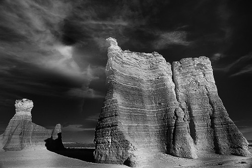
Monument Rocks, Kansas!?
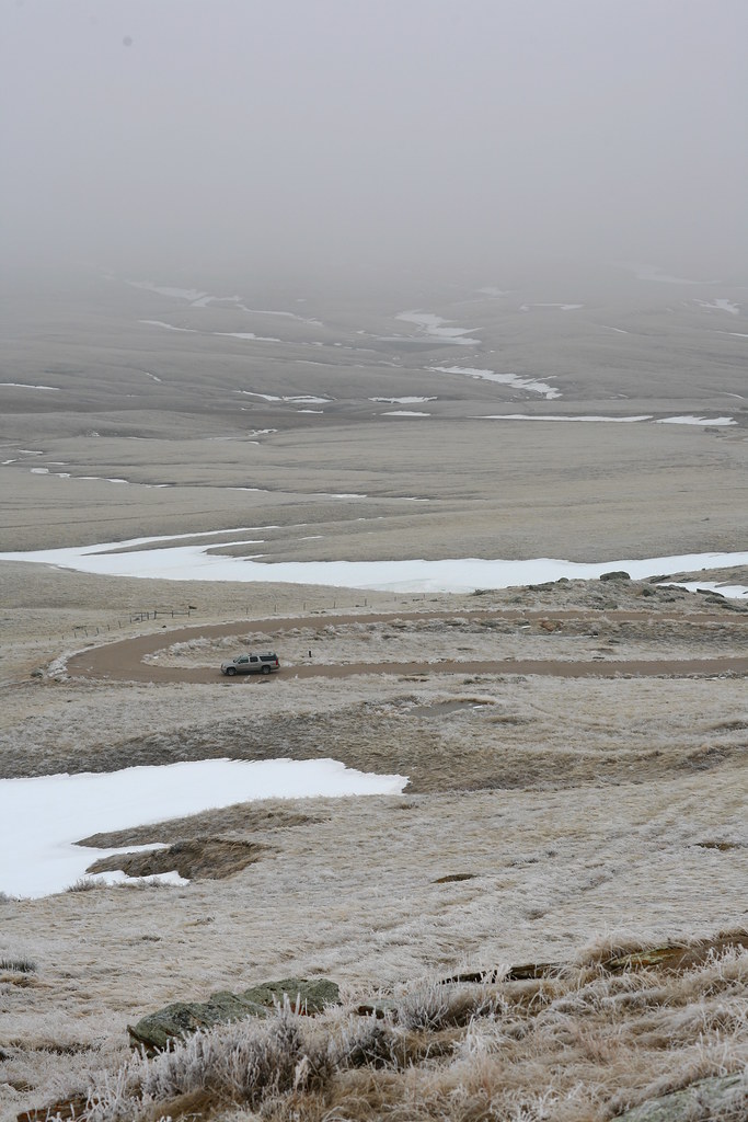
The next morning in Sidney, Nebraska my plan for the next two days is formulated: make Badlands National Park, scout the area, capture a sunset, arise early the next day for a sunrise, then head to North Dakota. From here to Buffalo Gap, South Dakota is about 3 hours, which will leave me more than sufficient time to find a great spot in the Park for the sunset shoot, given the fact it’s 7:00 a.m. and I’m already wheels up.
Passing the turn-off to ScottsBluff I again resist the urge to veer. Rather than see it with my own eyes once again, I pacify myself with this capture also from the Old West trip.
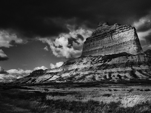
Scott's Bluff, Nebraska
It’s okay. You can admit you had NO idea Kansas and Nebraska held such topographic wonders. I didn’t either.
On these trips the human condition, its vulnerabilities and the multitude of cracks in its infrastructure become painfully apparent. I over-generalize. It’s MY human condition that rises so painfully to the surface. A small sign off highway 385 near Alliance, Nebraska calls my name – something about Car Henge. At the mercy of my hedonistic road trip tendencies, I’m off on a chase – a sucker for the weirdness of the American back road experience.
 Carhenge which replicates Stonehenge, consists of the circle of cars, 3 standing trilithons within the circle, the heel stone, slaughter stone, and 2 station stones, and the Aubrey circle, named after Sir John Aubrey who first recognized the earthworks and great stones as a prehistoric temple in 1648. The artist of this unique car sculpture, Jim Reinders, experimented with unusual and interesting artistic creations throughout his life. His desire to copy Stonehenge in physical size and placement came to fruition in the summer of 1987 with the help of family. Thirty-eight automobiles were placed to assume the same proportions as Stonehenge with the circle measuring approximately 96 feet in diameter. The honor of depicting the heel stone goes to a 1962 Caddy.

WAIT!!!! It gets even MORE Fun!

I'm not sure what statement this is supposed to make, but it was entertainment at its finest.
Treasures of the Dakota Plains
Veering from Highway 385 onto 79, then onto the first unmarked road heading east, the Badlands are nowhere to be seen but the expansive Pine Ridge Indian Reservation offers enough gems to keep my camera clicking. The reservation is 2.7 MILLION acres, more than twice the size of Delaware and is home to the Oglala Lakota American Indian tribe, descendants of such famous warrior chiefs as Sitting Bull, Red Cloud, and Crazy Horse.
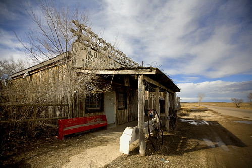
Dry Goods Store. Pine Ridge Indian Reservation, South Dakota
Originally part of the Great Sioux Reservation established under The Treaty of 1868, the reservation faces grave challenges. I left the reservation with photographic captures that are evocative, beautiful and especially poignant when you contrast them with the harsh reality of the human lives there. Passing the photos on to you for enjoyment, in essence taking away only the good from a place whose “bad” is in such opposition, doesn’t feel right to me. Love may be what makes the world go round, but awareness is what makes the turn worthwhile. From the Indian Youth Organization website: “With the exception of Haiti, life expectancy is lower here than anywhere else in the Western Hemisphere (men – age 48, women – age 52), infant mortality rates are the highest in the United States, and many families have no electricity, telephone service, running water, or sewers and must use wood burning stoves to heat their homes.” There are several grass roots organizations assisting with agricultural education and well-water management. If you’re interested in more, check out the website Running Strong for American Indian Youth.

Surrounded by steep drop-offs to the Badlands, this is an Oglala Lakota scaffold burial platform (representational, I presume). I'm a HUGE fan of the Old West so I knew what it was and while struck dumb by the Carhenge discovery, THIS sight had me needing smelling salts. Where's John Wayne when you need him? LOL Edward S. Curtis photographed one of these in 1908 and Captain Lewis noted the expedition's discovery of one in his journal dated April 20, 1805. "I walked on shore.killed two deer, wounded an Elk and a deer; saw the remains of some Indian camp, near which stood a small scaffold of about 7 feet high.underneath this scaffold a human body was lying, well rolled in several dressed buffalow skins and near it a bag.containing sundry articles belonging to the disceased. - Captian Lewis"

Edward S. Curtis 1908, courtesy www.old-picture.com

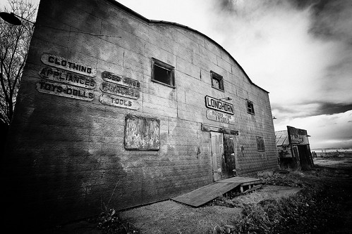
Longhorn Saloon, Pine Ridge Indian Reservation

This took some research. The sign was too much of a temptation to ignore so I pursued the arrow into a high plains pasture overlooking the edge of the Badlands. Asanpi Bleza "thin milk" was a Brule Indian warrior and the only known casualty of those seeking refuge in the stronghold during the Wounded Knee era. His bones were found by John Swallow, Sr. in 1948. Since Asanpi Bleza died without ceremony or burial, the family in 1948 conducted rites for him near the spot he was discovered.

Memorial erected near discovery of Asanpi Bleza's remains by John Swallow, Sr. in 1948.
By this time I’ve traveled via dirt road completely around the South Unit of the Badlands (meaning the reservation, which is NOT part of the National Park although they are purportedly working on some agreement). There are no access points for the sunset shot I plan to capture so I head to the North Unit. Clarification — there are no LEGAL access points. I’m aware I’ve been trespassing at certain points of the day, although I never knowingly violated posted signs. And every footfall has been VERY respectful. I’m certain that makes no difference, but I feel better about it.
The latter part of the day has been dreary and my hopes are not high for the glorious spread of slanted end-of-day rays so needed by the gray, bland Badlands. Racing around without a good map of the Park (yes, they’re open 24/7 but the entrances are not staffed this time of year, so no maps are handed out as you enter), I find this:

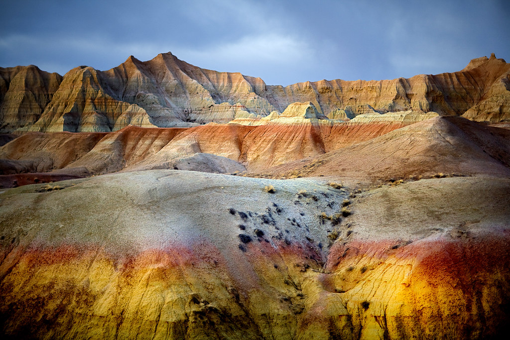
South Dakota Badlands. The Unexpected.
Not what you expected of the Badlands? Me either. A treasure indeed.
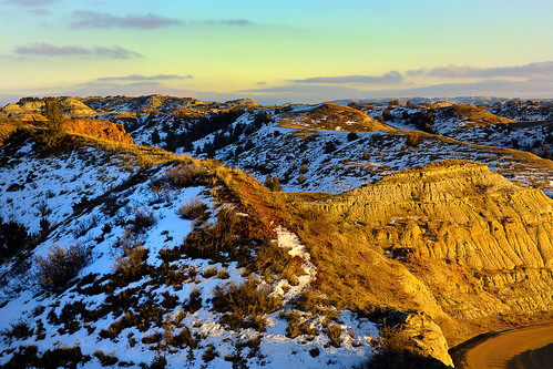
The day ends with this:

The Badlands
The perfect ending to a perfect day. Since I’ve previously made a complete post based on this one shot, I won’t bore you with a repeat. If you’ve not read about all that transpired for this to magically insert itself into my camera, click here (it’ll be worth your time, I promise).
The day actually ended with this:
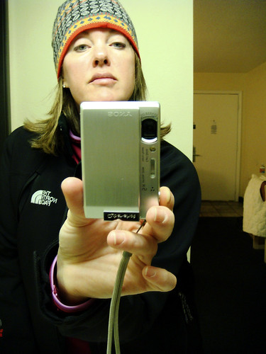
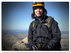
Weary Solo Road Tripper. No heat in her room. Too tired to care. Wall, South Dakota.
Deadwood Decadence & Really Bad Photography
Having taken my share of solo road trips that included sleeping in my car which necessitated sleeping in my clothes, some rather slovenly travel habits developed. Maturity has translated to a bit better overall effort in the personal presentation department on the road, so sleeping in my clothing now is a real treat, especially when I have an excuse good enough to hold all guilt at bay — like the malfunctioning heater in my motel room.
With plans to awaken at 3:30 a.m. for a Badlands sunrise shot (having bagged the sunset shot last night), sleeping in my clothes means I can throw back the covers, tie on my boots, and be on my way to the Park with hardly any time between sitting up in bed and sitting down in the truck. I should have included a bit more time for stumbling around at 3:30 a.m. “Note to self: more time for stumbling around for 3:30 a.m. sunrise shots.”
The sunrise shot was planned to the detail. Dogged by road trip weariness but determined to have bookend shots of the sun’s grandeur on the Badlands, every particular was meticulously given proper attention. Tripod, check. Remote cable trigger, check. Camera settings, check (and re-checked). Alarm clock, check. Wake-up call, check. Husband back-up call, check.

In lieu of a Badlands sunrise, I offer you this. LOL
Or how about this?!

SURELY you didn't think all my shots were well framed, artistic, or lucky? If only you knew the truth. Just to correct that fallacy, check this one out! How do you like this one?! Taken of the dashboard by accident as I rushed to get the camera in position to take yet another crappy shot of the deer crossing the road (above).
All efforts to prepare ultimately translated to a BIG FAT failure thanks to the archaic-every-6-months tradition we have here, called a TIME CHANGE — as in “spring forward, fall back”. It’s stupid. I’m stupid. This morning everyone and everything is stupid. Already an hour off from having driven from the Central Time Zone to the Mountain Time Zone, another hour adjustment was just too much for Tammie’s world order. My own failure was soothed only by the failure of others – the motel and my dear husband – they both failed to calculate the time change as well.
Rushing to the Park I get there just in time to witness the zenith of the rising sun. My camera however doesn’t get to participate. As I’m toying with the thought of going back to the cold motel room and taking a short nap, I take a short nap. Thirty minutes later the road to Deadwood calls. After a re-fuel and a cup of coffee, the disappointment gives way to thoughts of chocolate sugarplums and the meeting of a person whose friendship has been cultivated by the internet.

The Genius behind The Chubby Chipmunk, Chip Tautkus. Deadwood, South Dakota
You must be ready at all times to walk through the door of friendship opportunity. Embrace the fact it’s always just around the corner. Your life can be guided in new and wonderful directions like a joyous labyrinth when you recognize one very important fact: If you reach out to people, they reach back. While the success rate is not 100%, when “it” clicks and another person’s life is added to yours (and vice versa) in a meaningful connection of personalities and dreams, it’s like finding that gold nugget at the bottom of your pan. Not only is it rewarding on its own, but it gives new vitality to the quest for more.
 My original discovery of The Chubby Chipmunk is documented here. It’s a great story that has developed and morphed and grown into a part of my life — made more so by the meeting of the woman with whom I began an email correspondence after my first encounter with her chocolate dream factory in October 2007. Chip Tautkus, owner/chocolatier of The Chubby Chipmunk and I met over coffee in her shop soon after I pulled into town (mere hours after the Badlands sunrise debacle). We’d arranged the meeting over the phone before I’d left Oklahoma. Neither of us could remember the other from my original visit until we sat down and began talking about what all had transpired for me to have walked through her door that first time. We talked non-stop for an hour. I photographed the shop, ate samples, bought stacks of truffles to bring home and departed with a friendship now forged by a bit of face-time and the indisputable knowledge that the connection made via email was just as significant, just as true, just as “easy” as we’d both already suspected. We could have gone our lifetimes never having met and had the same rewarding connection. That’s one of the enrichments the internet has given our lives. But getting to face each other just that once was the icing on the cake for a lifelong friendship. I’m so glad for that day in October 2007 when I walked up to the door and read the hand scrawled note that said “Closed Monday for nut gathering”. Friendship history.

Chocolate Sugarplum Display
Aces & Eights
Walking around with thumbs hooked in my front belt loops makes it difficult to fire off shots. Camera shots of course. Spending a good deal of time with my nose to pistol case windows, my mind plays out a fantasy of swishing down the dirt streets with a long, black duster one side tucked to reveal a fancy hand-tooled holster and matching silver plated, ivory handled Colts. It would be difficult however to win a gun fight with my black hat tipped this low over my eyes. The same tender spot on my forehead would likely result from tipping the hat back and forth, similar to the stocking hat incident in the Badlands. Not cool.
Burned to the ground in 1879, Deadwood was rebuilt on the burned out remains. The original town sits about 10 feet lower than street entrance today.
No trip to the Badlands is complete without a trip to Deadwood. Jen Laceda, of Folie a’ Deux fame take note! Resistance to the Wild West aura of Deadwood, South Dakota is futile my friend. You will be sucked in. And glad for it.
Designated a National Historic Landmark in 1961, in the 1870’s lawlessness defined Deadwood. Illegally settled on Native American Land as a result of Custer’s discovery of gold in the Black Hills, gambling, prostitution, gunfights, and general mayhem was the order of the day. Which is juicy enough, but the town gained its current fame upon the murder of James Butler Hickok, aka Wild Bill in 1876.

The Historic Adams House was built in 1892 by Deadwood pioneers Harris and Anna Franklin. Local contemporary press described the home as "the grandest house west of the Mississippi." Today the house operates as a museum devoted to the history and culture of the Deadwood area.

Deadwood Courthouse on a Modern March Morning

While in several notable gunfights, Wild Bill was NOT an outlaw, although his penchant for gambling overlapped nicely with his law enforcement duties. [You know that deserves a chuckle.] Wild Bill had many callings: abolitionist, facilitator of the Underground Railroad Movement, lawman (serving as a US Marshal at Ft. Riley, Kansas for a short period, sheriff of Hays, Kansas and marshal of Abilene, Kansas), gambler, veteran of the Union Army in the American Civil War, and scout. Holding the infamous “dead man’s hand” of two Ace’s and two 8’s, (the 5th and last card having been undealt), he was gunned down from behind by Jack McCall during a poker match. Wild Bill was 39. McCall hanged on March 1, 1877 for the murder.
Wild Bill’s life began in Illinois. He traveled from there to Kansas, Nebraska, Missouri, Indian Territory (Oklahoma), New York, Wyoming, and South Dakota. An interview published by Harper’s New Monthly Magazine in 1865, another by Henry Morgan Stanley a Welsh journalist and famed African explorer in 1867, and later being cast as the hero of the earliest dime store novels, resulted in Wild Bill becoming one of the first international celebrities. For someone aged 39 at a time when most travel was at 3-7 miles per hour, his life covered a whole lot of ground.

Several locations claim to be THE spot where Wild Bill was shot. I chose this one well, because it made a great pic!

Original Wild Bill Grave Site
Wild Bill Hickok? Buffalo Bill Cody? Calamity Jane? Wyatt Earp? Did they know each other? What were the connections? What was the timeline on these American West Icons?
Let’s start with Calamity Jane – there’s got to be a woman mixed up in all this, right?! Martha Jane Cannary, aka Calamity Jane, a frontierswoman and scout became friends with Wild Bill Hickok in Deadwood, South Dakota. While Calamity Jane purportedly claimed they married and Wild Bill fathered a child, these claims have never been proven. Most historical accounts indicate Jane was indeed infatuated with Wild Bill but the romantic liaison was fabricated. Calamity Jane later became a horse rider and trick shooter in 1893 for Buffalo Bill Cody’s Wild West Show. She died in 1903. Her dying wish was to be buried next to Wild Bill Hickok. She now lies interred beside him in Mt. Moriah Cemetery, Deadwood, South Dakota.
Wild Bill Hickok met Buffalo Bill Cody (purveyor of the Wild West Show that gained international fame in the late 1800’s) during their short but common stint with General Jim Lane’s vigilante Free State Army (“The Red Legs”) in 1855. Buffalo Bill was only 12 years of age, scouting (reconnaissance) for the General. Wild Bill was 21. They became life-long friends, their paths crossing many times before Wild Bill’s demise in 1876. Wild Bill played a part in Buffalo Bill’s show “Scouts of the Plains” along with Texas Jack in 1873. They left the show circuit well before the famed “Wild West Show” began.

Wild Bill Hickok, Texas Jack, and Buffalo Bill Cody. 1873.
In 1871 Wild Bill Hickok and Buffalo Bill Cody met Wyatt Earp for the first time in Kansas City. Wyatt claimed Wild Bill helped him become a skilled buffalo hunter. Wyatt met Bat Masterson on the open Kansas prairie during a hunt on which Wild Bill accompanied him. While there’s not much documentation indicating their paths crossed much, Wyatt said of Wild Bill “Bill Hickok was regarded as the deadliest pistol shot alive as well as being a man of great courage. The truth of certain stories of Bill’s achievements may have been open to debate but he had earned the respect paid to him.”
To put all their ages in perspective, Wild Bill Hickok was the oldest being born in 1837. Buffalo Bill Cody and Wyatt Earp were 9 years younger than Wild Bill with birth dates in 1848. Calamity Jane, born in 1852 was 15 years younger than Wild Bill.

Mt. Moriah Cemetery. Deadwood, South Dakota. Final resting place for Wild Bill Hickok and Calamity Jane.

This shot was literally “captured”. Fortunately, I wasn’t. Breakin’ the law.
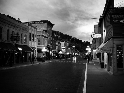
Today Deadwood is a mecca for gambling with every false storefront tucking away a casino. If you’re a gambler, then any time of year works. If you’re not (I’m not), I’d recommend October. This last visit was only weeks ago in March and while it was off-season as far as crowds go, it was also cold enough to keep most people inside. And that’s NOT where you want to be. October was divine. I had Main Street to myself. Sitting on a bench one evening, the stars bright overhead, gazing down the lamp lit street, I was transported to another place and time.

I went to bed viewing the scene above from my hotel room window. The black duster thrown over the back of an imaginary chair, the matching Colts on an imaginary table, I slept with a smile on my face.
Late, For Nowhere in Particular
Rolling down some back-road cloaked in the bliss of anonymity, one arm in contact with the wheel at the point that encourages my wrist to flop carefree at the end of it, head bobbling to a slow rhythmic beat that doesn’t match my rousing vocal accompaniment to Life is a Highway that’s cranked up so loud it’s oozing from the crevices of the Yukon like displaced mortar, I come across this.
THIS is temptation. THIS signifies a certain head toss to the grinding pressure of today’s world, a ballsy show of throwing caution to the wind. If you look at it with just the right tilt of your head, you’ll get the same glint in your eyes. Selling everything I own would enable the purchase of a few acres in any number of states, on which I could move or build a small house, delivering my bobbling head into town once a week for provisions in THIS.
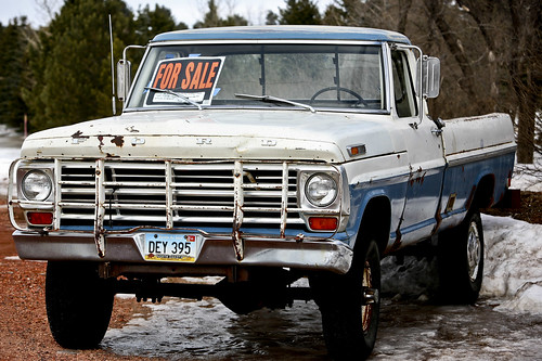
I don’t succumb. Others in my life would highly disapprove and I highly value these others. I photograph the Ford and pull back onto the road with a slow-mo melodrama moving frame by frame through my brain. It conveniently loops from the part that shows me walking up to the house, knocking on the door, engaging the owner in negotiations, taking the keys from them and driving away into the sunset in that truck. My melodramas never include the pragmatic part about what I’d do with all my crap in the Yukon, the Yukon, the exchange of titles, discussing what oil the Ford uses, insurance, etc.
Not many of us ever throw this degree of caution to the wind. But who among us hasn’t entertained the thought of running away from home, even if it’s for a mere few harmless days? It’s a bit risque and for the first time in my long history of SRTs I see it for that. You’re out there by the droves sending me emails about the longing to get out there. I fully understand the longing. Few things in our lives are as liberating, empowering, and rejuvenating as a solo road trip.
So I ask all of you with latent and repressed open road wanderlust sitting at home fantasizing about the cloak of anonymity, arm draped over the wheel, or resting lightly on handle bars, aren’t you late, for nowhere in particular?
Of Rattlesnakes & The Geographic Center of the U.S.
Clamoring on the steep incline under the weight of my heaviest film camera (reserved only for the most promising of discoveries), slipping twice to one knee on rime ice, I hitch one last gasp of frigid oxygen as my head lifts my eager eyes into perfect position to feast on the conquered monument. Sheepherder’s Monuments!? !*&#@%! “This is NOT the Geographic Center of the United States of America??!!” My lips are too numb to spew anything out, but my mind handles it beautifully in their stead. “I climbed all this way, alone in the middle of Greenland, South Dakota for THIS!?” Kicking the fence while hanging on with one gloved hand to steady my footing, the shards of ice and frozen atmosphere target the only opening to my skin, right down the back of my neck. And if there’s any justice, hopefully into the dens of a few sleeping rattlesnakes.
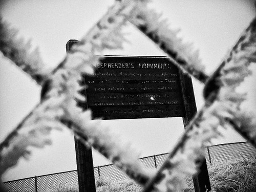
"Sheepherder’s Monuments or stone Johnnies survive the days of the open range. These stone columns were probably built to indicate distance and direction to waterholes and provided the sheepherder with a pastime while herding his flocks."
The Geographic Center of the U.S. is not where you’d expect. Furthermore, it’s not where my 2004 Atlas said it would be. After spending an hour-and-a-half combing the area, I know. North of Belle Fourche (Bell Foosh), South Dakota on Highway 85, just South of Junction 168, my Atlas in bright red said: “Geographic Center of U.S. Marker”.
From setting my sights on a grandiose solo road trip self-portrait at the geographic center of the United States of America, the search dwindled to looking for something as tell-tell as a unique T-Post in the frozen fence line. Incredulous the grandiose was not forthcoming, I became desperate to find something and perplexed as to what could have happened to a marker of such importance. Blood pressure increasing, my eyes landed on the remnants of an old paved road. No gates, no signs, with just enough pavement and old footings to indicate something of note stood here at one point, I excitedly drove around the site to get my bearings. Perched above the disintegrating pavement and towering above the prairie was an area surrounded by a menacing fence. Without question this was something the Department of Interior had gone to great lengths to protect — I’d discovered it after all.
Confused? So was I. So here’s my best shot at an explanation. But I warn you, there’s not a lot of authoritative research to rely on and a lot of what follows is disputable. In 1959 the U.S. Coast and Geodetic Survey officially designated a point 13 miles north of Belle Fourche, South Dakota as the Geographic Center of the U.S. (which includes Alaska and Hawaii). The location was surveyed at: Latitude 44 degrees, 58 minutes North, and Longitude 103 degrees, 46 minutes West. Any marker grander than the requisite USGS benchmark in the ground was up to the state of South Dakota to provide and maintain. Around the same time, maybe AT the same time, the Department of Interior built the Monument marker and fence (since it’s on Bureau of Land Management land) for the nearby high-plains cairns of Sheepherder’s Monuments. The State of South Dakota then proceeded to build a picnic area, restrooms, etc. on the site and sold tickets billed for seeing both monuments. Recall previously I mentioned the footings for buildings and the video shows restrooms.
The rattle snakes must have felt they weren’t being cut their fair share and laid claim to the area. Either the Department of Interior, the state of South Dakota or both, closed and abandoned the Sheepherder’s Monuments’ area in the mid-1990’s. Solo road trippers, caution is ALWAYS justified and should NEVER be disparaged. What you don’t know can kill you. There were no signs warning of rattlesnakes. Had I gone in any of the 3 other seasons of the year…well, I was wearing hiking boots. Given that I’m here to tell this tale, I learned a lesson and should I be faced with such a situation again, I will recall this hell-bent mission to see something and hopefully make a good decision.
Eventually the Belle Fourche Chamber of Commerce approached the National Geodetic Survey with a plan to build a new concrete and granite marker IN the town of Belle Fourche making it easier to share the marker with the world. The National Geodetic Survey agreed to the new location and contributed the stainless steel centerpiece of the monument. It was unveiled in 2007.
The original marker STILL LIES 13 miles North of Belle Fourche off highway 85 on someone’s fence row, seldom visible, and is but a footnote in history, if that. It’s the marker I want to see.

The original USGS benchmark made in 1959 -- NOT my photo.
From the top of Sheepherder's Monuments. While not locating the Geographic Center of the U.S. marker, seeing Sheepherder's Monuments, in retrospect turned out to be a very exciting find. I'm glad I made the trek.
WARNING LABEL: If you decide to venture out of Belle Fourche to locate the original Geographic Center of the U.S. or anywhere in the above discussed areas, BEWARE of Rattlesnakes.
From Medora to Moorhead
The desire to travel has no correlation with positive impressions despite the travel industry’s ardent efforts to convince us otherwise. I’m often moved to action by emotional responses that would have the experts gnashing their teeth (in which I happen to take a bit of pride). National Geographic ran “The Emptied Prairie” in January 2008. From the title down, there was nothing on pages 140 – 157 that remotely resembled the enticingly glossed travel magazines in the same row of offerings that day in the book store. I could have been transported to any number of magical destinations, delivered there by the heady claims of paradise and rejuvenation, discovery and adventure. Instead, I plucked the mundane. The Emptied Prairie left me morose. And hell-bent to see North Dakota exactly as Nat Geo had depicted it – gray, cold, forlorn.
Our backgrounds dictate how we receive input and mine told me there was a “spin” on this story. I too live in a prairie state. Signs of human migration wrought from disappointment dot the landscape here as well. My hometown of Soper, Oklahoma has a population of 300; the High School serves 85 students. The town is in the most impoverished county in the state. On a gray, rainy day it too appears to be on its last leg and a sense of melancholy and abandonment is pervasive.
As much as the Nat Geo article and photographs smacked of gloom and despair, my life has proved the glamorous to be at times a bit rough around the edges and the forlorn to be enticing.
Early March seemed a good time to see for myself what Nat Geo had surely missed.
My attempt to mimic Nat Geo's portrayal of the North Dakota prairie.
Medora, North Dakota
Theodore Roosevelt National Park
Theodore Roosevelt National Park
The plan from the start was to see North Dakota from end to end. Entering the state on it’s far western border from Highway 85 (two hours later than planned) because of the hunt for the Geographic Center of the U.S., I’m tempted to call it a day. Snowfall in the Western part of the state has been unusually heavy over the 2008-2009 winter, meaning road conditions demand attention.
But not enough to override the recognition night is about to throw it’s protective cover. And with that dimming comes glorious shadows, wildlife stirrings, sunset kaleidescopes, and the overall suspense that lovely, unexpected things happen when the light wanes. Joy spreads through my tired limbs leaving no room for thoughts of the creature comforts of a motel room. I drive into T.R. National Park.

Theodore Roosevelt became the nation's 26th President in 1901. He said "I would not have been President had it not been for my experience in North Dakota." The Park includes Roosevelt's Elkhorn Ranch and was designated a National MEMORIAL Park in 1947. It didn't achieve full National Park status until Jimmy Carter gave the approval in 1978.

Mule Deer
See what I mean about lovely surprises?
A Patriotic Drive: Mt. Rushmore & Beyond
The grandeur of granite rising from the cliffs of Mt. Rushmore will in one upward glance sweep away any countryman’s negative sentiments. And impress the hell out of everyone else. Mt. Rushmore is but one impressive sight however among many packed into the Southwestern corner of South Dakota.

Air Force One over Mt. Rushmore. Wikimedia Commons.
From my SRT in 2007.
Overview
Anchored by Rapid City (airport code RAP), the Black Hills area still echoes with the report of Wild West Colt pistols. You can wander through Native American Indian Reservations as you contemplate what to take in first — the sights of Mt. Rushmore featured on the big screen in National Treasure: Book of Secrets, the cavernous limestone formations of Badlands National Park, Sturgis or the frontier town of Deadwood. Throw in the Crazy Horse Memorial, Custer State Park, Wind Cave National Park, the 1880 Train, Buffalo Gap National Grassland, the Geographic Center of the U.S., or the Minuteman Missile National Historic Site, and a week’s vacation can be easily spent in one of the most scenic and pivotally historic areas of the lower 48 states. And that’s before you even cross into Wyoming. Forget the guidebook, you’ll need only your Atlas and a penchant for discovery.
Badlands National Park, SRT 2009
The Route: starting in Rapid City
Interstate 90 East of Rapid City will deliver you to Wall, South Dakota. If you’re already parched or ready for a stop, the Wall Drug Store offers refreshment, take in the National Grasslands Visitor Center, or search for the Minuteman Missile Silo. From there 240 South will take you directly to the scenic drive around the North Unit of Badlands National Park. The loop ends at Interior. To continue into the South Unit’s 2.7 million acres of sprawling erosion of the Pine Ridge Indian Reservation, proceed past Imlay to Scenic, turning South at the first/only turnoff. You’ll need to stop at the White River Visitor Center to get permission to proceed into the Reservation. West on Highway 2, then North on Highway 40 to Redshirt will complete the South Unit. “Highway” 2 is a misnomer. The road is gravel, albeit wide and well maintained. Continuing past Redshirt on Highway 40 to Hermosa presents the choice of turning North on Highway 79 and back to Rapid City, or west on Highway 36 to 87 South to Custer State Park and Wind Cave National Park. From Wind Cave National Park you can easily hit 385 North taking you to Custer, the Crazy Horse Memorial, Mt. Rushmore, and the ‘1880 Train’ in Hill, as you progress northward.
Scenic, SD. SRT in 2009.
Native American Burial Platform -- South of Redshirt on Highway 40. SRT 2009.
The area is deceptively compact. While distances aren’t great between any point (from Rapid City to Hot Springs on 79 is only 57 miles) you will not desire to cover any of it quickly. And the twists and turns of the roads preclude speed. While limited lodging is available in the smaller towns and in Badlands National Park, the high season summer months make day trips to and from your pre-reserved lodging in centrally located Rapid City conducive to combing the area.
Deadwood
Once you’ve exhausted the sights south of Rapid City, 385 will take you to Lead (as in lead a horse to water), Deadwood, the Geographic Center of the U.S. in Belle Fourche, and Sturgis to the East just off Highway 90. Either of these towns is worthy of securing lodging if you’re ready to venture past the Rapid City anchor. Summer is high season though and Sturgis along with towns in the area are choked with bikers for the annual Bike Week Rally usually the first week in August.
Deadwood is a personal favorite. Wild Bill and Calamity Jane are buried in the Mt. Moriah cemetery. Saloon 10 is where Wild Bill made famous the Dead Man’s poker hand of Aces & Eights when shot from behind by Jack McCall (hanged for his crime). The town, while a haven for gambling is replete with history and the nostalgic charm of false storefronts.
Deadwood, SD. 2009 SRT.
Regarding FOOD, if you’ve got a nose for chocolate on the road, stop by The Chubby Chipmunk for a fix. For lunch, try the Deadwood Thymes Bistro. The last time there I had the White Bean & Chicken Chili, a Three-Cheese grilled sandwich with bell peppers and a slice of apple all melted together between perfectly browned, thick sliced bread, and a large, cold, creamy slab of their Peanut Butter & Chocolate Pie. I was hungry; the meal memorable. I’d like a repeat, please. For dinner I sat one night on a perch over downtown Deadwood in the 2nd story location of Kevin Costner’s Sports Bar & Grill (above the Midnight Star casino on Main Street). While I don’t recall the food in the same longing manner as the lunch from Deadood Thymes Bistro, I do fondly remember the view and the numerous photos/posters of Kevin Costner in his Western movie roles.
A Wyoming Detour
Since you’re on the border and you could add another state-notch to your holster belt, or you’ve got another day or two to burn, why not venture into Wyoming? Devil’s Tower National Monument is a quick drive and well worth the time. Take Highway 90 to Sundance, Wyoming. From there head north on 14 for a few miles. Or if you’re sticking to the backroads, Highway 34 west out of Belle Fourche (turns into 24 at the Wyoming border) will get you there as well. Should you venturing here during the off-season, don’t count on lodging nearby. There IS lodging, but…
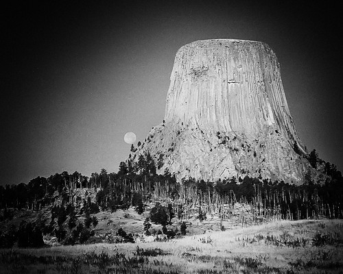
Devil's Tower National Monument, Wyoming. High ISO FILM. See the moon?!
President Theodore Roosevelt Proclaimed Devil’s Tower the first National Monument in 1906. Many Plains Indians have legends associated with “Bear’s Lodge” and consider it a sacred site. The Kiowas legend goes like this: Kiowas were camped by a stream where there were lots of bears. Seven little girls were playing away from their village and bears took chase. The girls ran and just as the bears were about to catch them, they jumped on a low rock. One of the girls began to pray. The rock began to push itself out of the ground raising the children higher and higher. The deep grooves running down the sides are said to be made by the bears attempting to claw their way to the top. The rock continued to push the children upward into the sky so far they reside in the sky today as the pleiades star cluster.
This Great American Drive will compel you to sing the Stars & Stripes and purchase a long, black duster. Be prepared.
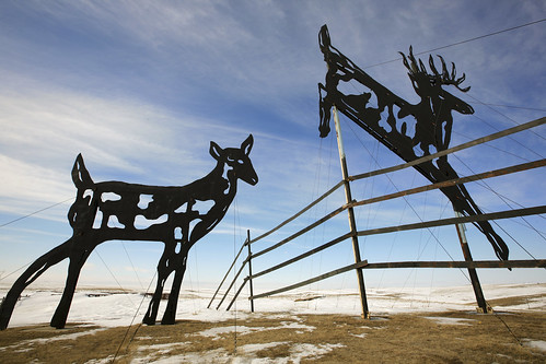
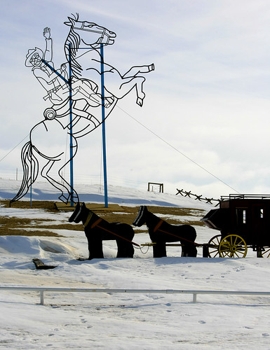
The Enchanted Highway
North Dakota’s Enchanted Highway is 32 miles of soaring, metal art sculpture that qualify as some of the largest in the world. They are as unusual as they are enjoyable, qualifying unequivocally as must-see Americana Road Art. But the highway isn’t about the objects at all. North Dakota’s Enchanted Highway is about a MAN and his singular vision.
Small town characters/sometime heroes are sometimes an odd lot. My husband and I swap stories about the characters from our respective small towns – his in West Virginia, mine in SE Oklahoma. Those characters, as we call them, were a bit different, marched to the beat of a not-so-audible drum, hardworking, kind, and talkative. In a small town these individuals are part of the community’s colorful tapestry. They are a clean stamped part of the puzzle, fitting in while not being forced to lose their identity. And while this is commendable of small towns, they are at the same time frequently guilty of speaking from both sides of their mouth. On the intake they can welcome uniqueness with invitations to “come here” while on the exhale uttering whispers of displeasure and not-so-silent “get aways.”
Gary Greff is a small town character. I only hesitate to say “hero” as I feel I don’t know enough of the story. However if you judge such things based not on the outcome but intent and the effort expended, then Gary qualifies. Near 60, Gary hails from a small town to which he was never able to break the tether (Regent, ND), lives below the poverty line but is tenaciously steeped in hope for his own life and for the survival of his hometown, and has spent the past 20 years fighting for a vision of betterment for his community. His young life in Regent was re-directed by tragedy. At 16, driving a motorbike with his 15 year old brother on back, Gary hit a curb in town. His brother died at the scene. People’s lives are shaped by such.
After teaching school in various communities, at age 40 Gary moved back to Regent led by a vision to do something to curtail the demise of his hometown. He’d never pursued art of any kind. He couldn’t weld. And yet the sculpture below made it into The Guinness Book of World Records as the World’s Largest Metal Art Sculpture. It’s 110 feet tall, 154 feet long and weighs 79 tons. And photographs like any beautiful piece of art.
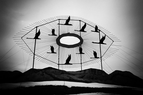
Geese in Flight
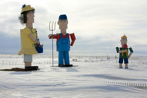
"Tin Family". The man is 45-feet tall; the woman 43-feet tall; and the boy 23-feet tall.
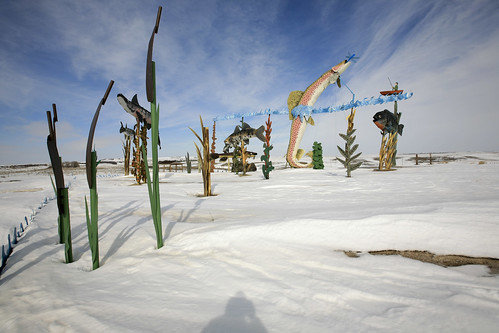
"Fisherman's Dream" (my personal favorite).
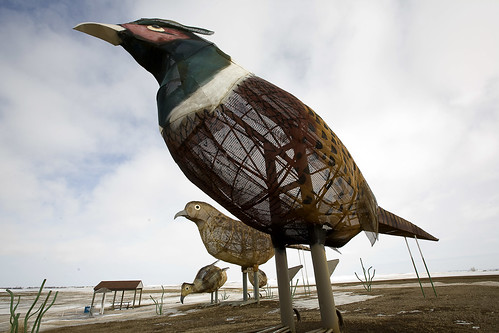
- “Pheasants in the Prairie”. Rooster is 70 ft. long, 40 ft. tall. Made of wire mesh that was originally used for screening gravel. Long process — took 3 years — the wire was heated and bent to form the bodies.
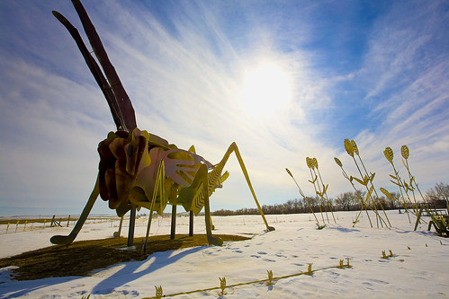
- “Grasshopper’s Delight”. 60 Feet long, 40 Feet tall. A reminder of the hardships farmers have overcome making their living off the land. Welded from old fuel tanks and oil well tanks.
Gary Greff between 1989 and 2006 did all of this. And he did it amid harsh criticism, ridicule, accusations of insanity, the scorn of fellow townsfolk, one rebuff after another, and over time a severely curtailed financial and volunteer donor list. His brother Brad said, “people walked across the street to avoid him”. He did, what no other townsperson in Regent, ND has been able to do – he drew people to the area. And continues to.
Gary’s art didn’t save Regent in the way he’d envisioned. The High School closed. The town appeared to me to be a rural American small town clutching survival when I saw it in March 2009. Gary’s dream for an Enchanted Highway Theme Park and droves of tourists dropping their money in Regent hasn’t materialized. But his vision, hard work and undying commitment left a commendable and very memorable mark. Gary Greff is the best kind of dreamer – he takes action.
To see the Enchanted Highway and Gary Greff’s art, take Exit 72 (about 20 miles east of Dickinson, ND) off of I-94. The Highway runs due south from there and ends in Regent. There is no charge so if you see a contribution box, leave some currency behind.
“No one, I discover, begins to know the real geographic, democratic, indissoluble American Union in the present, or suspect it in the future, until he explores these Central States, and dwells awhile on their prairies or amid their busy towns.” – Walt Whitman
Heartland Chronicles is a series of radio documentaries set in and around Middle America, exploring the region’s people and communities. A concentrated focus on this region allows us to draw what author William Least Heat Moon refers to as a “deep map” – a careful, long-term exploration of place that reveals the truth of everyday life today. Here’s the 2005 interview with Gary Greff (the MP3 choice seems to work best).
 About SRT... I’m a traveler, writer and photographer for whom the open road frequently summons. Adventurous solo road trips are a staple for me, and a curiosity. So I created this website to share them and inspire you to step out and give them a try. Welcome!

I really like your site. I enjoy your writing style and photos. Please keep traveling. I am starting a blog site and plan on using it on a 6 week trip to Europe. I have traveled in an RV across the US and in the southern states. Thank you for sharing.
Comment by Bob S. — August 24, 2016 @ 9:20 am
Hi! Just read your indian scaffolding comment. The one you saw was most likely real! I witnesses a ‘burial’ on an indian scaffold about 10 years ago on the Cheyenne River Sioux Reservation in SD. No photos were allowed to be taken, out of respect for the deceased. They are still used (for 3 days after death) to this day. I love all of your photos and comments. I think SD is one of the most beautiful and fascinating states in the union.
Comment by Christina Meade — July 6, 2011 @ 7:19 pm
Great Book! I like the personality of the book most of all. Who is your greatest audience for the sale of your book? like.. Age group, population, area of states or towns? Thank you.
Comment by Judy Hill — January 6, 2011 @ 3:35 pm
there are some beautiful shots there i hope to see some of these places where did you stay any good B&Bs at all? keep blogging writing thanks
Comment by Laura Brisbane — May 24, 2010 @ 7:11 pm
What amazing photos. What kind of camera did you say you had? Do you think such great results can be achieved with standard cameras?
Wow. Great blog, thanks!
Comment by Laura Annerley — May 10, 2010 @ 8:29 pm
Fantastic journal entry, thank you for sharing your terrific shots as well. Certainly makes me want to pull on the old travellin’ boots and sling my Nikon over my shoulder. (BTW, nothing even remotely crappy about the deer running across the road shot, I love it). Unfortunately, not being a millionaire precludes me from flying to the US and doing a coast-to-coast drive. But your shots make me want to do that.
Comment by Paul C — May 29, 2009 @ 9:47 pm